


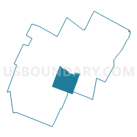
Berlin Voting District, Washington County, Vermont
About
Outline

Summary
| Unique Area Identifier | 680909 |
| Name | Berlin Voting District |
| County | Washington County |
| State | Vermont |
| Area (square miles) | 36.94 |
| Land Area (square miles) | 36.27 |
| Water Area (square miles) | 0.67 |
| % of Land Area | 98.19 |
| % of Water Area | 1.81 |
| Latitude of the Internal Point | 44.20414670 |
| Longtitude of the Internal Point | -72.60976290 |
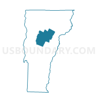
Maps

Graphs
Select a template below for downloading or customizing gragh for Berlin Voting District, Washington County, Vermont


Neighbors
Neighoring Voting District (by Name) Neighboring Voting District on the Map
- Barre District 3, Washington County, VT
- Barre Town Voting District, Washington County, VT
- East Montpelier Voting District, Washington County, VT
- Middlesex Voting District, Washington County, VT
- Montpelier Voting District, Washington County, VT
- Moretown Voting District, Washington County, VT
- Northfield Voting District, Washington County, VT
- Williamstown Voting District, Orange County, VT
Top 10 Neighboring County Subdivision (by Population) Neighboring County Subdivision on the Map
- Barre city, Washington County, VT (9,052)
- Barre town, Washington County, VT (7,924)
- Montpelier city, Washington County, VT (7,855)
- Northfield town, Washington County, VT (6,207)
- Williamstown town, Orange County, VT (3,389)
- Berlin town, Washington County, VT (2,887)
- East Montpelier town, Washington County, VT (2,576)
- Middlesex town, Washington County, VT (1,731)
- Moretown town, Washington County, VT (1,658)
Top 10 Neighboring Place (by Population) Neighboring Place on the Map
Top 10 Neighboring Elementary School District (by Population) Neighboring Elementary School District on the Map
- Barre City School District, VT (9,052)
- Barre Town School District, VT (7,924)
- Berlin School District, VT (2,887)
- East Montpelier School District, VT (2,576)
- Middlesex School District, VT (1,731)
- Moretown School District, VT (1,658)
Top 10 Neighboring Secondary School District (by Population) Neighboring Secondary School District on the Map
- Spaulding Union High School District 41, VT (16,976)
- Harwood Union High School District 19, VT (12,836)
- Union High School District 32, VT (9,799)
Top 10 Neighboring Unified School District (by Population) Neighboring Unified School District on the Map
- Montpelier School District, VT (7,855)
- Northfield School District, VT (6,207)
- Williamstown School District, VT (3,389)
Top 10 Neighboring State Legislative District Lower Chamber (by Population) Neighboring State Legislative District Lower Chamber on the Map
- Orange-1 State House District, VT (8,835)
- Washington-2 State House District, VT (8,556)
- Washington-4 State House District, VT (7,924)
- Washington-5 State House District, VT (7,855)
- Washington-7 State House District, VT (4,307)
- Washington-3-3 State House District, VT (3,789)
Top 10 Neighboring State Legislative District Upper Chamber (by Population) Neighboring State Legislative District Upper Chamber on the Map
Top 10 Neighboring 111th Congressional District (by Population) Neighboring 111th Congressional District on the Map
Top 10 Neighboring Census Tract (by Population) Neighboring Census Tract on the Map
- Census Tract 9555, Washington County, VT (6,898)
- Census Tract 9551, Washington County, VT (4,530)
- Census Tract 9552, Washington County, VT (4,522)
- Census Tract 9553, Washington County, VT (4,054)
- Census Tract 9554, Washington County, VT (3,870)
- Census Tract 9592, Orange County, VT (3,389)
- Census Tract 9544, Washington County, VT (2,995)
- Census Tract 9545, Washington County, VT (2,887)
- Census Tract 9542, Washington County, VT (2,729)
- Census Tract 9550, Washington County, VT (2,576)